


What do you do when a trip, more than a year in the making, involving five friends, falls apart at the last minute? You adapt.
I, along with a small group of some of my closest friends, have been completing a long-distance sea kayaking expedition for the last few years. We started with Lake Pend Oreille, then we completed upper and lower Priest Lake in the second year. On our third iteration, we decided we would step outside of North Idaho and head west to Diablo and Ross lakes in North Cascades National Park. Unfortunately, that one didn’t work out. Everyone but myself and my friend Dave Spoelstra, one of the original members of the group, had to bail out.
Dave and I decided almost simultaneously that Ross and Diablo lakes weren’t in the cards for this trip. Instead, we chose a mystical, fairly obscure, yet stunning place in Montana named Hungry Horse Reservoir. Months earlier, we had plotted out the mileage, did some preliminary e-scouting, and had put it on the list of destinations to circumnavigate for a future trip. That future trip was now, and we were ready.

Day 1: 16 miles
With the day of the trip upon us, I met Dave at his house around 5 a.m. We would spend five days on the water and another night at the launch point, which was on a remote bay on the lake with no amenities. We would be finishing the trip late in the afternoon of the fifth day and camping another night in the wilderness before heading home.
We loaded the truck and set out. After several hours of driving, we navigated our way onto a lonely stretch of dirt road and headed into the unknown. This place was new to us and the only familiarity was from scouting via satellite imagery. We finally pulled out of the forest where the road ended at what would be the water’s edge in the summer. Interestingly, Hungry Horse is a reservoir and the water is released from the dam on its north end in autumn to prepare for the following year’s spring melt, resulting in the lake being drawn down about 20-30 feet.
Dave and I were blown away by the beauty of the place. Looking south and west out of the tiny bay; the mighty Swan Mountain Range towered over the lake’s western edge. Little did we know that the mountains immediately to the east would be even more mind blowing. We were surprised to find that the forest in this part of Montana was much more like what we were familiar with back home; taller and denser underbrush between more closely spaced larch and fir trees.
We locked the truck and lugged our 200-pound boats down to the water and set off knowing nothing other than the fact that we were embarking on another epic adventure. Despite a late start, we had a relatively short 16 miles to paddle to our first planned camp on a tiny island on the northwest section of the lake.
Since it was only Dave and I on this trip, we made a pact that we would aim to paddle at least 100 miles over the course of the trip, hugging the shoreline as closely as possible and paddling as many of the inlets as we could. Despite the numerous tree stumps that sat millimeters under the surface, we managed to stay within 25-75 feet of shore all day, every day. Laughing every time one of us would narrowly miss a stump as we paddled along the incredibly clear water.
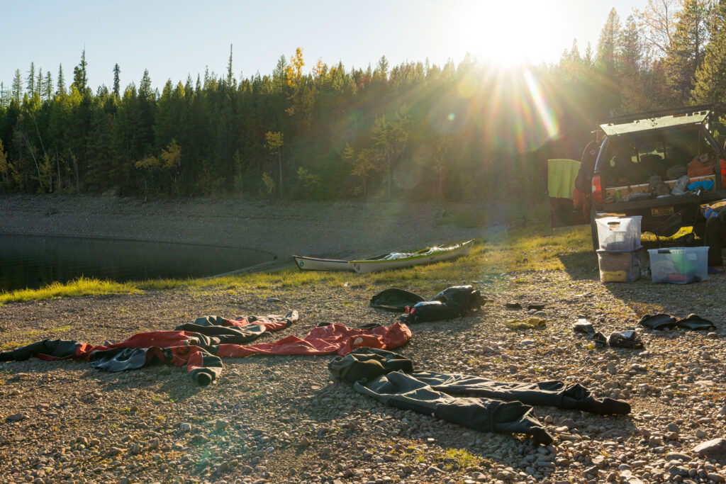
We heeded out of Emery Bay and headed west, then north in awe of this newfound beauty we were experiencing. There was the lightest breath of wind, taking a little bit of the edge off of the heat from the sun overhead. We commented how we did not regret the decision to stuff the drysuits into the few remaining square inches of space inside the kayaks before setting off, as weather during the rest of the trip would not be as mild.
We finally rounded a corner out of one of the many little bays on the lake and could see the northern terminus of the reservoir. The horizon line was filled by the gigantic concrete megalith that was the Hungry Horse Dam. Built over five years and completed in 1953, the dam towers 564 feet over the lower canyon of the South Fork Flathead River. The Morning Glory Spillway is the tallest in the world, and the hydroelectric generators in the dam provide electricity for the surrounding communities. We paddled up to the log boom stretching across the entire lake about 300 yards before the dam itself, turned left, crossed the lake and began heading south. We would paddle consistently south for the next 2.5 days to the southern tip of the lake and the mouth of the South Fork Flathead.
Four hours and 16 miles later, we paddled up to our intended campsite for the night — a tiny island about 300 yards from the western shoreline of the lake. During the planning phase, we decided we would try our best to avoid official campgrounds and people in general, hoping for a more pure and isolated wilderness experience.
We had no idea what to expect as we wandered up the beach to the top of that tiny forested island. Given that we were hammock camping, we needed the right tree spacing and a lack of brush to set up for the night. As we walked up into the middle of the island, there was a clearing we could see up ahead; quickly we realized we had stumbled upon an absolutely perfect primitive campsite. The tree spacing was excellent, the campfire ring was well built and there was even a fire poker left behind by another camper. As if things couldn’t get any better, we had unbroken views of a line of towering, craggy peaks along the eastern shoreline of the lake.
After a somewhat restless night of sleep, we woke just before the sun peeked over the top of the towering peaks to the east. We trudged through our morning routine, breaking down camp and playing the daily game of stuffing gear in the correct combinations into the various sized and colored drybags that only fit in the boats a specific way.
Day 2: 16 miles
There was a slight breeze that would eventually calm down as the day progressed; however we watched the weather like a hawk. There was a severe storm forecast to hit late in the afternoon and was predicted to bring 60 to 70 mph winds, heavy rain and even snow. It was initially forecasted to last through the following day, which could easily put our trip in jeopardy.
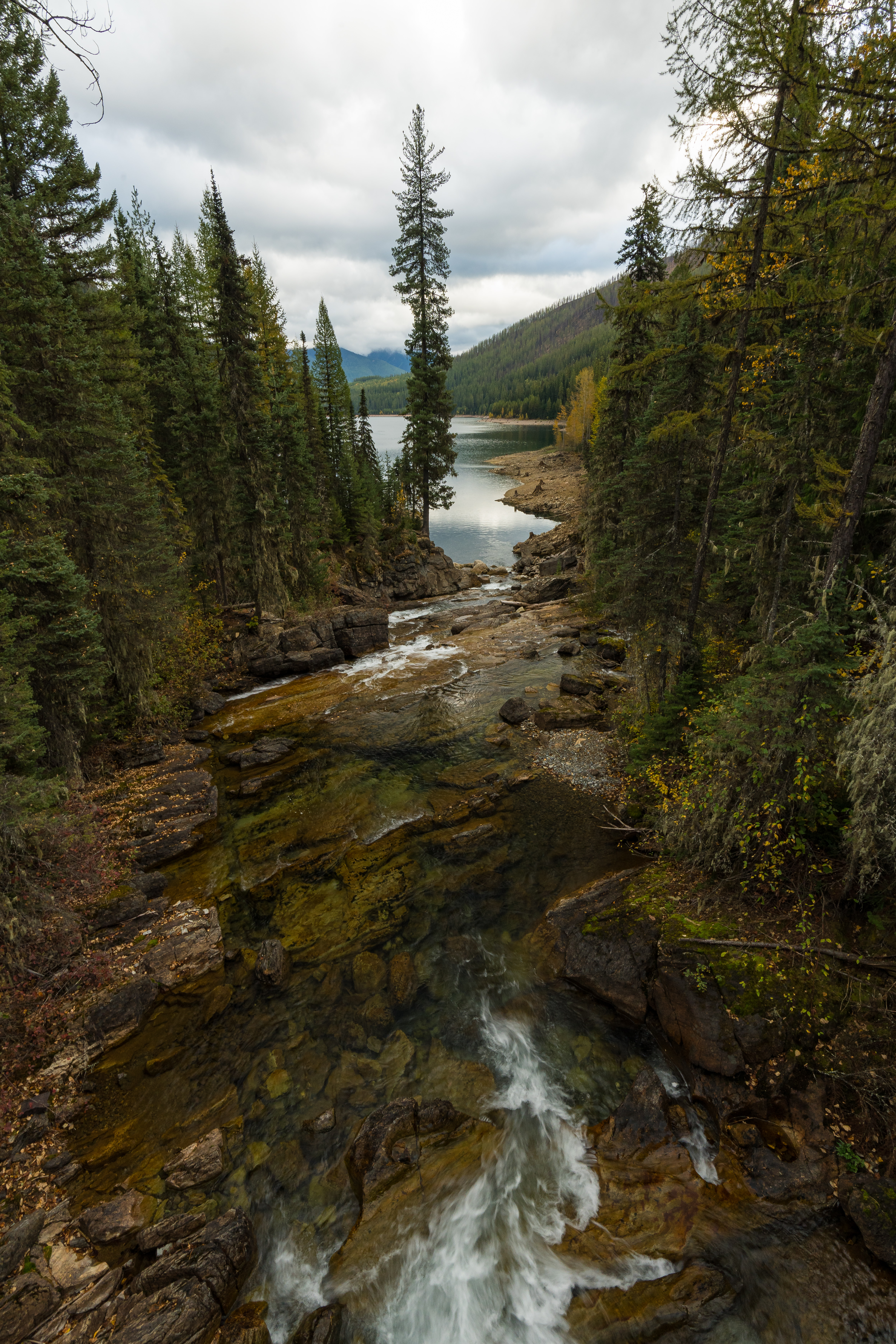
As we paddled south we hugged the shoreline, dodged hundreds of tree stumps and had too many incredible conversations to remember. One of the many amazing features of the lake are the many long fingers that are actually smaller rivers that feed the main reservoir. During the first three days we were able to paddle up all of these inlets along the western shore. Several of them stretched more than 2 miles into deep canyons culminating in stunning waterfalls.
In fact, that is where we ended day two. Half way down the lake after another 16-mile day. Our last 5 miles or so was spent hurriedly, or determinedly, paddling into the inlet to beat the approaching storm. The wind gusts began almost immediately, but fortunately for us, the torrential rain didn’t begin until after we had settled into camp and jumped into the 40-50 degree water below a massive waterfall that poured into the lake next to camp. We needed the rest and recovery, as day 3 was planned to be our longest of the trip; planned at about 23 miles. Little did we know that the day would end being even longer.
Story continues after a quick message from our sponsor below.

Day 3: 27 miles
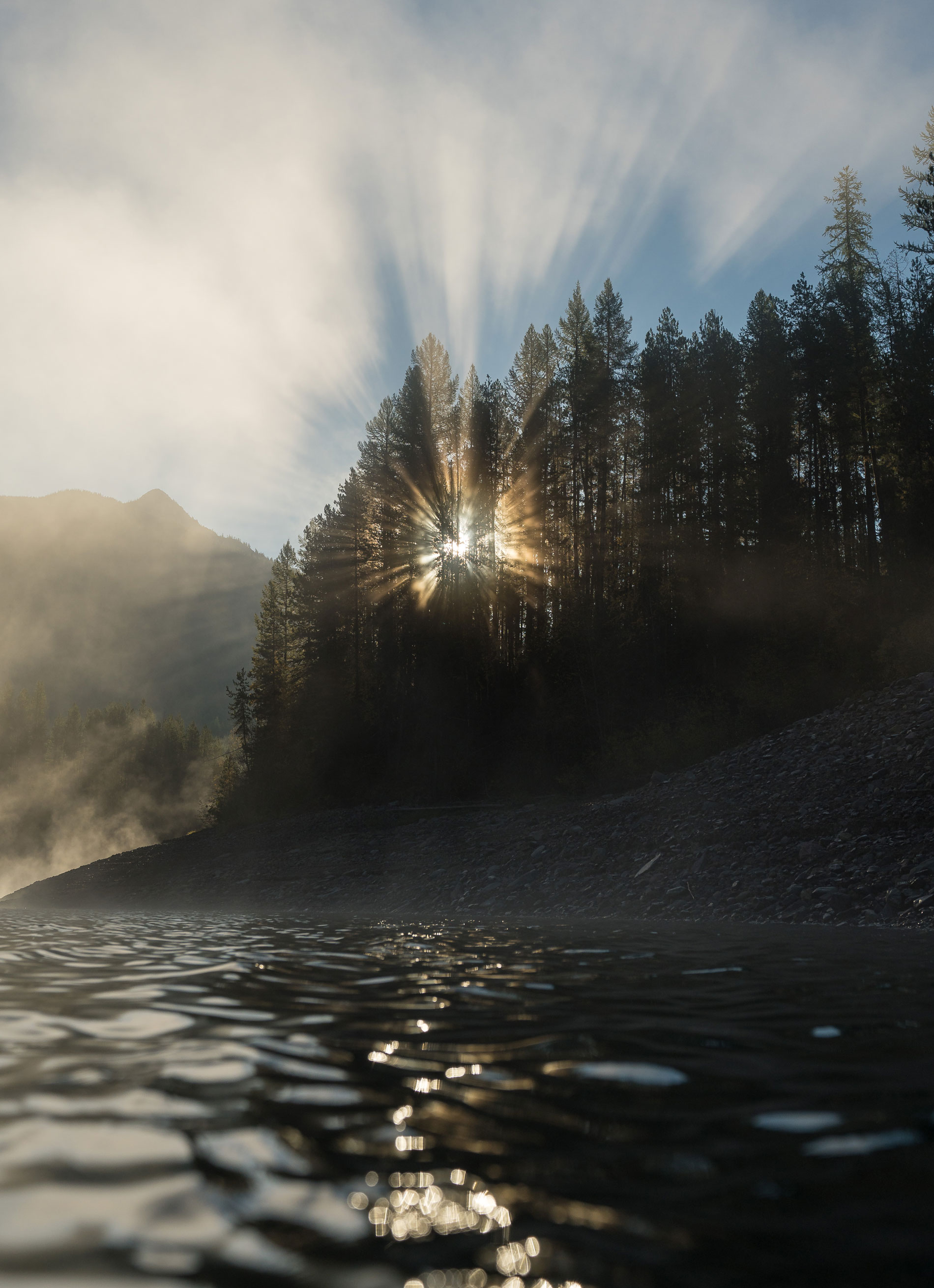
To our surprise, we woke the following morning to fresh snow in the mountains above us. However, the wind that was supposed to be accompanied with the cold and snow was instead replaced by big puffy post-storm clouds and bright sunshine lighting up the lake. We breathed a sigh of relief knowing that we may not have to backtrack two days to the truck.
The morning paddle south was stunning with glass-like conditions on the water, big white puffy clouds and blue skies. To top it all off, the nights of near-freezing temperatures forced the deciduous trees to pop even more brilliantly with autumn color. By midday we could finally see the end of the lake. As we paddled farther south, the wind picked up quickly at our backs. The final couple of miles to the very southern end of the lake, and the mouth of the inflowing South Fork Flathead yielded some amazing downwind surfing on nicely formed wind waves. We stopped for a quick break at what looked like an abandoned and long-forgotten primitive campground that had obvious signs of fresh bear vandalism, and then quickly left, not wanting to meet the individuals responsible for the damage.
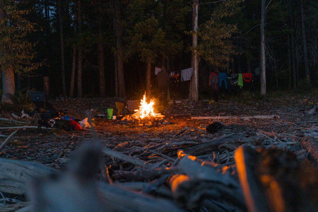
We got back into our boats beginning to feel the miles paddled the last 2.5 days. Only now we were faced with the thing we had hoped to avoid; a ferocious and sustained headwind with another 6-7 miles ahead of us before getting to camp. Our initial camp was a no-go, so we paddled another several miles into the wind before finally settling on a place. In all, we paddled over 26-27 miles that day. We got to camp exhausted but for the first time had an abundance of dry firewood to build a large bonfire before heading to bed absolutely wiped out.
Day 4: 23 miles
Despite an overall good sleep, the wind picked up again overnight and was ferocious once more. It was also our coldest morning to that point. We got up early to make sure that we could get on the water and underway as quickly as possible. We had another 20-plus miles to paddle on our fourth day in. We settled for a quick but calorie-dense breakfast, packed the boats and were on the water right after the sun came up. We were met with white caps and fog blowing around the lake. Our only solace was that it was a tailwind.
As the day progressed, and we made our way north, the winds slowly died down and a high pressure system moved in. We finally stopped after about three hours of consistent paddling, realizing we had already paddled over halfway through our mileage for the day. We chose a tiny, 10-foot diameter island with a single stump in the middle of it. Just enough to stretch our legs, grab a quick snack, and enjoy the incredible scenery of the southern half of the lake one last time before paddling back through the narrow passage that seemed to divide the upper and lower part of the lake.
After finding that our planned island camp wouldn’t suffice, we consulted the map and realized that there was a boat launch and small campground about a mile farther north that would give us the vitamin D exposure we sought. This was the first time during the trip that we utilized an actual campground; the picnic table, fire pit and level campsite were welcome additions.
Sitting around the fire that night, it was obvious how tired we were. We ended up paddling another 23 miles that day, bringing us to 50 in two days and over 80 in the previous four. We were both nodding off between discussions of how we planned on hitting our 100-mile goal.
The original track that we plotted only brought us to about 90 miles for the trip. Despite paddling every nook and inlet as closely to the shoreline as possible each day, we were still about 20 miles short of our goal. Our original plan had factored in a lighter day of paddling to finish off the trip at about 15 miles; we knew if we did that we would end up short of our goal. We rerouted a course on the map and calculated that we should be able to paddle approximately 20-23 miles and achieve our goal. WIth that, we crawled into our hammocks and crashed hard.
Day 5: 23 miles
As we launched into another frigid morning, a beaver swam by and out of sight around the corner as mist rose from the water as far as we could see. We continued to paddle northward up the lake, then east into one of the last two large inlets and bays. As we rounded a corner, the largest peak bordering the eastern edge of the lake came into view towering above us with that amazing reddish brown dirt. The cove we were paddling into was filled with low-lying fog, and the sun, having just come up above the ridgeline, created crepuscular rays through the trees and mist. We paddled on into another tiny cove, then another, and another. We saw multiple loons and a few mergansers swimming around in the early morning light as well.
The rest of the day was spent chatting and knocking off mile after mile of shoreline. Midday came and went, and 10 miles, then 15 miles came and went. We finally passed 100 miles less than 2 miles from our original launch point. We both breathed a sigh of relief that we weren’t going to have to paddle in circles before getting out of our kayaks. We exchanged a quick fist bump as we drifted into the place where we set off five days prior, having just paddled 101.4 miles in total. The paddling portion of the trip was officially over. All that was left to do was set up camp one last time to enjoy one more night in the Montana wilderness before making our way back home the following morning.
As seen in the 2025 Summer/Fall edition
By: Chris Celentano